The Charnwood Local Plan policies maps show the location of sites across the borough which have been proposed for housing, employment and retail, as well as environmental safeguards such as open spaces, areas of separation and countryside.
The policies maps also indicate locations for sustainable energy sources.
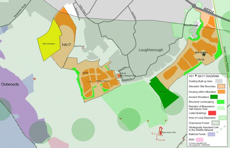
In addition, there are a series of local area maps which show in closer detail our proposals for the development of some of our larger housing sites. These local area maps also show details such at the extent of development, buffers for landscaping and required key infrastructure such as new roads and schools. They make careful consideration of how development fits alongside existing built up areas and countryside.
The two main policies maps can be found below:
- Policies Map 1 - Charnwood Local Plan (PDF Document, 33.72 Mb)
- Policies Map 2 - Charnwood Local Plan (PDF Document, 16.77 Mb)
The diagrams provide a visual guide to help with the interpretation of our policies for particular sites.
Anstey
- Anstey - Local Plan Site Diagram (HA12) (PDF Document, 0.12 Mb)
- Anstey - Local Plan Site Diagram (HA43) (PDF Document, 0.22 Mb)
Barrow upon Soar
- Barrow Upon Soar - Local Plan Site Diagram (HA49) (PDF Document, 0.14 Mb)
Birstall
- Birstall - Local Plan Site Diagram (HA14) (PDF Document, 0.1 Mb)
East Goscote
- East Goscote - Local Plan Site Diagram (HA60) (PDF Document, 0.13 Mb)
Hathern
- Hathern - Local Plan Site Diagram (HA61) (PDF Document, 0.15 Mb)
Loughborough
- Loughborough - Local Plan Site Diagram (HA16) (PDF Document, 0.41 Mb)
- Loughborough - Local Plan Site Diagram (HA17) (PDF Document, 0.38 Mb)
- Loughborough - Local Plan Site Diagram (HA18) (PDF Document, 0.23 Mb)
Queniborough
- Queniborough - Local Plan Site Diagram (HA64 and HA65) (PDF Document, 0.18 Mb)
Quorn
- Quorn - Local Plan Site Diagram (HA15) (PDF Document, 0.26 Mb)
Syston
- Syston - Local Plan Site Diagram (HA1) (PDF Document, 0.15 Mb)
- Syston - Local Plan Site Diagram (HA7) (PDF Document, 0.13 Mb)
Last updated: Thu 15th July, 2021 @ 15:06